Pages

Friday, June 25, 2010

Week 26/52 - Yalgoo & Monsignor Hawes - entering the "outback"

Welcome everyone to week 26 of my 52 week tour Downunder Western Australia.

This week we official cross over into the "outback"

After visiting the Perenjori tourist bureau for a wildflower update, we continue north to Morawa. From here you can take the gravel Morawa-Yalgoo Road to Yalgoo or continue north on the bitumen to Mullewa.

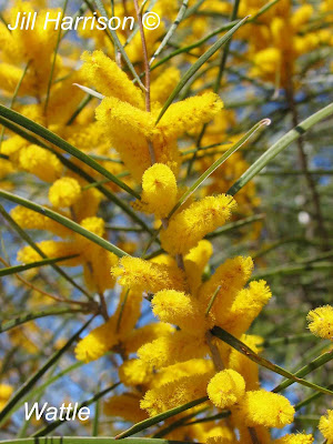
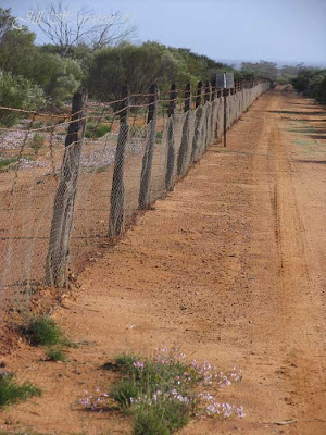
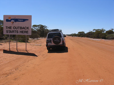
We head towards Yalgoo and passing a sign which proudly announces we are now in “The Outback”, we enter station country, where yellow Silver Cassia, Grevilleas, Wattles and everlastings flower in bright contrast against the dark red dirt. In this photo you can see the road running straight ahead into the distance and the white everlastings lining the road.


From Life Images by Jill

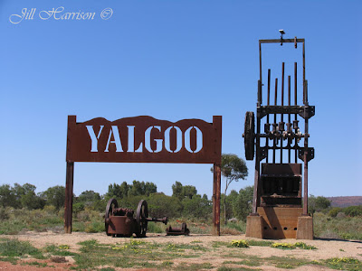
Yalgoo, which is part of the Wool Wagon Pathway and the Miner’s Pathway, two of the Gascoyne Murchison Outback Pathways historic routes, was settled by prospectors in the early 1890’s. Many old mine sites and relics can be explored in the area, including Jokers Tunnel, a tunnel carved through solid rock by early gold prospectors. Rich in gold mining heritage, little remains of this once thriving town.

This is a photo of Yalgoo's entrance statement.

From Life Images by Jill

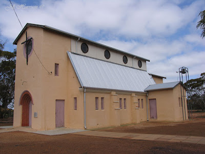
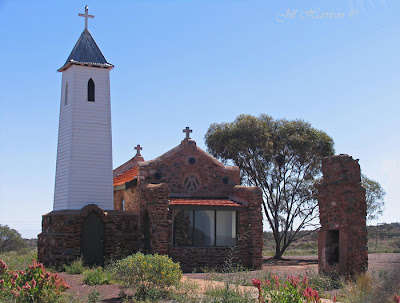
Yalgoo has a number of historic buildings including the tiny Dominican Chapel of St Hyacinth, which Monsignor John Hawes built for the Dominican Sisters in 1920 when he brought them to Yalgoo to run the school.

From Life Images by Jill

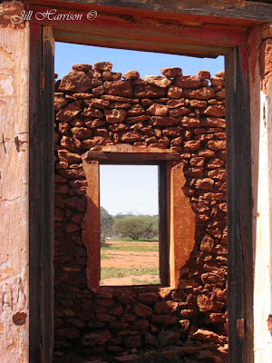
Remains of an old station homestead. Do you like the framing I've done in this photo?

From Life Images by Jill

I just love the north. The southern forests are so beautiful, but there is something special about that red dirt and the wide open spaces of the Pilbara and Kimberley.

I often think what a lonely life it must have been for those first settlers in the desolate outback. My grandmother included, who was taken out into the bush and expected to raise children in a hut with a dirt floor while my grandfather was away a lot of the time.

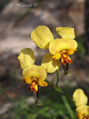
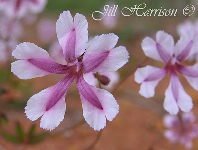
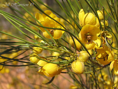
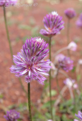
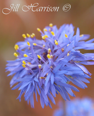
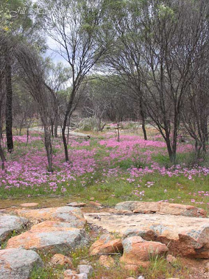
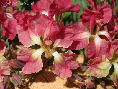
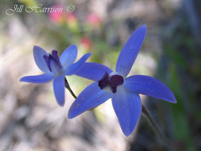
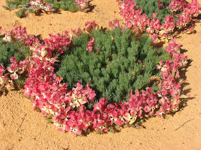
To get the most out of any wildflower drive, you should stop the car on the roadside verges or nature reserves and walk into the bush, as it gives you the opportunity to find flowers you won’t see travelling along the highway. Even areas which appear arid at first glance can reveal hidden treasures. We would have never seen the “Dainty Blue Orchid” (photo below) which we had never seen before if we hadn’t ventured off the road. Many flowers are more exquisite close up, and different soil types will produce different plant varieties. It is a good idea to photograph the flower, leaves and environment, or take notes, to assist with identification in a wildflower book later.


From Wildflowers
At Pindar, we turned north onto the Beringarra-Pindar Road towards Tallering Station. About ten kilometres along we found a large stretch of the unique Wreath Leschenaultia growing on the sandy road verge.

From Wildflowers

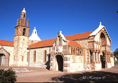
Back on the main road we continue to Mullewa, home of the greatest number of Monsignor Hawes’ religious buildings. The Church of Our Lady of Mount Carmel and the Holy Apostles St Peter and St Paul were built in the style of a Romanesque church typical of Italian or Spanish village churches. You can also visit the former home of Monsignor Hawes, now the Priest House museum.

From Life Images by Jill
Next week we will continue on to the historic gold town of Cue.

Tuesday, June 22, 2010

Week 25/52 - Part 2 - Western Australia's everlasting magic - Perenjori & Canna

Hi everyone, and welcome to Part 2 of Week 25 of my 52 week tour Downunder Western Australia. I decided that this week need to be divided into two parts, so that I could show you more from the midwest of Western Australia.

From our last destination Camel Soak and John Forrest Lookout we are going to drive westward to Perenjori in the heart of the mid west wildflower region. Perenjori is situated on the north eastern edge of the wheat belt, beyond which lies the station country of the Murchison.

Native orchid lovers should visit Canna Dam north of Perenjori. Many varieties of native orchids can be found along the walk trail around the dam.

This little guy is the Ant Orchid. To me he looks like a clown in striped pants. These guys are quite small and are very hard to see, they grow under the trees. Lucky for me my husband has a very good eye for finding orchids.


From Wildflowers
This flower is the Podolepis.

From Wildflowers
Yellow and white everlastings at Canna spreading through the trees like a carpet.

From Wildflowers

Perenjori is the southern gateway to the Monsignor Hawes Heritage Trail visiting 15 churches constructed between 1915 and 1939 in the Midwest by the architect priest, Monsignor John Hawes. Each church on the Trail is different and has its own particular characteristics.

This is the Hawes church in Perenjori.

From Life Images by Jill
Here is a photo of the main street of Perenjori. It is very similar to many wheatbelt towns in Western Australia.

From Life Images by Jill
And wattle at Canna Dam.

From Wildflowers
and the Donkey Orchid.

From Wildflowers

Friday, June 18, 2010

Week 25/52 - Camel Soak & John Forrest Lookout - in the steps of explorers & fence builders

Hi everyone and welcome to week 25 of my 52 week tour Downunder Western Australia. We are still in the mid west wildflower region as we continue to travel northwards from out last stop at White Wells.

North of White Wells we turned west off the Great Northern Highway just past Mount Gibson onto Wanarra East Road, a well maintained graded dirt road along which the everlastings were giving way to Pink Velleia.

The road passes through Charles Darwin Reserve, formerly White Wells sheep station, purchased in 2003 by Bush Heritage Australia with money partly donated by Chris Darwin, Charles Darwin’s great-great-grandson. The Reserve protects remnant woodlands and the native animals and plants that depend on them. Closed to tourists, volunteers are involved in the Reserve’s conservation and management.

Our camp for the night is Camel Soak, located 30 kilometres east of Perenjori. The Number 1 Rabbit Proof Fence, built to stop rabbits invading the West, stretches 1,837 kilometres from Cape Keraudren on the North West coast to Starvation Harbour on the South coast. The men constructing the 1166 kilometre long Number 2 Fence between 1903 and 1906 camped at Camel Soak as the gnamma holes on the granite outcrop provided water for the men and their camels. Gnamma holes are natural depressions in the rock. When it rains the water collects in these depressions. Gnamma holes were used by Aboriginals and later explorers as a source of water. The aboriginals would visit favoured holes and keep them clean.

This is a view from the rock at camel soak, showing gnamma holes.


From Life Images by Jill
Nestled at the base of the rock under shady trees, Camel Soak is a pleasant place for an overnight camp. The surrounding bushland was covered in wildflowers, so as soon as our tents were pitched we went walking with our cameras.

There were wildflowers all around our camp. I spent quite a while wandering around the area near our camp taking photos of the different types of wildflowers.

From Life Images by Jill
This is the road into Camel Soak lined by a carpet of the wildflower Velleia.

From Life Images by Jill
Here is a close up of the Velleia.

From Wildflowers
some more wildflowers. This is the Silver Cassia.

From Wildflowers
And one of the varieties of Mulla Mulla - you see great swaths of Mulla Mulla all over the Pilbara.

From Wildflowers

This is the rabbit proof fence - or now called "the vermin proof fence" The Rabbit Proof Fence,was built in the early 1900s to stop rabbits invading the West from the Eastern states of Australia. It stretches 1,837 kilometres from Cape Keraudren on the North West coast to Starvation Harbour on the South coast. (unfortunately the fence was unsuccessful in stopping the rabbits!)

From Life Images by Jill

Further east we come to John Forrest Lookout from where the spectacular panoramic of the surrounding station country reaches to the horizon in an undulating sea of scrubland splashed with the colours of spring.

The Lookout forms part of the Damperwah Hills which Sir John Forrest (explorer and later WA’s first premier) discovered and named in 1869 when searching for missing German explorer Ludwig Leichhardt, and used as survey point during his expedition to Cue and Day Dawn in 1897. Granite outcrops like these were often used by early explorers as survey points and lookouts, camp sites, and for watering their horses.

Here is the view from the top. The 750 metre walk up to the Lookout is not difficult and the dry scrubland was covered in wildflowers. There is a shady picnic area at the base of the hill, which would make a good overnight camp.

From Life Images by Jill
Thanks for looking everyone. I hope you have enjoyed these few extra photos, I look forward to hearing from you, and continuing further north with you on our journey. __________________

Friday, June 11, 2010

Week 24/52 - Western Australia's midwest wild-flower carpets

Welcome everyone to week 24 of my 52 week tour Downunder Western Australia.

This week we continue northwards from York and Toodyay our last destinations through New Norcia and up into wildflower country - I hope you have your cameras, and plenty of memory space ready for some wonderful photographic opportunities along our wildflower drive. Luckily our driver knows the call "stop the car!" when we see yet another new lot of wildflowers to photograph. Of all the places in Western Australia going north to photograph wildflowers is my favourite way to travel during spring. If the season is good (and it can vary from year to year depending on rains) the wildflowers are spectacular!

Heading north via the Great Northern Highway we visit Australia’s only Monastic town, New Norcia, a Spanish-influenced religious settlement founded by Dom Rosendo Salvado for the Benedictine Monks in 1846. Registered as a National estate, several hours could be spent here touring the beautiful buildings, 27 of which are classified by the National Trust.

This is St Ildephonsus at New Norcia.

From Life Images by Jill

Continuing north, we collected information from the Dalwallinu Visitor Information Centre as we knew from previous experience that local information is invaluable to know what is flowering where, as the best locations can vary each year depending on the season.

Influenced by rain and sunshine and boasting up to 12,000 known species, the Western Australian wildflower season spreads over several months starting from July in the north’s Pilbara region till November in the south. It is no wonder the Western Australian wildflower season attracts thousands of tourists to the Midwest every year from all over the world.

Stopping along roadside verges and nature reserves and walking into the bush gives you the opportunity to find flowers you won’t see travelling along the highway. It is a good idea to photograph the flower, leaves and environment, or take notes, to assist with identification in a wildflower book later.

This is Dampiera - with rain drops....

From Wildflowers
Our first major stop for wildflowers is Jibberding Reserve - a photographers’ delight, as the carpets of everlastings and a kaleidoscope of wildflowers including the blue native cornflower were spreading out through the trees on mass. We have been here several times on our way north and it always delights. It is amazing how the wildflowers erupt from the seemingly dry dirt during spring.

This is the blue native cornflower...

From Wildflowers

Further north we had lunch under the shady trees at White Wells. We have camped here in the past overnight - it is a good overnight camping spot away from the highway and traffic noise. Here the carpets of pink everlastings were everywhere, dotted with sprinklings of white and yellow everlastings and other wildflowers.

Here is the pink everlasting.......

From Wildflowers

You have heard me talk about carpets of wildflowers - well here is a photo of a carpet of everlastings - in a good season it is like this everywhere in the mid west region of WA - stunning isn't it.... I would really like to show you a more expansive view, but that scrappy dry bush gets in the way - but I hope you get the idea.

By the way they are called everlastings (or paper daisies) because when you pick them you hang them up in a bunch upside down and they last for years.

From Wildflowers

We’ve been told that the Wreath Leschenaultia, is in flower on Sanderson Road, and as I’d never seen them before I was excited at the prospect. I am not disappointed. Not far along Sanderson Road, the wreaths appear, sitting on the sandy road verge like giant cream buns, their pink and cream flowers surrounding their green centres in perfect circles.

Here is a close up of the Wreath Leschenaultia...

From Wildflowers
And a wider view - amazing aren't they...

From Wildflowers
There are thousands of varieties of wildflowes in Western Australia. Photographing them and finding varieties I haven't seen before has become a bit of a passion. But with so many gorgeous wildflowers can you blame me?

This is a close up of the Emu Tree.

From Wildflowers

Thank you for looking everyone. I hope you are enjoying the wildflower photos this week. I really want to show you some more wildflowers. So stay tuned for Week 25 and week 26 when we explore more of the Midwest.

In case you hadn't realised I LOVE photographing wildflowers and feel incredibly lucky to have such a huge variety virtually on my doorstep - I don't have to go far to find some variety of wildflower flowering.

Here is another - this is the Goodenia -

From Wildflowers

Friday, June 4, 2010

Week 23/52 - York - History preserved in stone

Hi everyone and welcome to week 23 of my 52 week Tour Downunder Western Australia.

We have left the beaches behind when we left Esperance last weekend and have hot footed home to re-stock, do the washing and repack in readiness for our trip North. We will be travelling "outback" through the north west for the next part of the tour and it will be a few months before we see the ocean again.

But first on our way north we will visit the historic town of York.

Situated in the rolling hills and fertile grazing country of the Avon Valley, just 96 kilometres from Perth, York is WA’s oldest inland town and one of Australia’s best preserved nineteenth century towns. Settled by farmers in 1831, only two years after the establishment of the Swan River Colony, York became the starting point for pastoralists, sandalwood cutters, explorers and gold seekers.

Now a popular tourist centre full of cafes and shops, York is proud of its history and is classified by the National Trust.

The York Heritage Trail is divided into four walks, each taking about two to three hours and covering 57 historical sites. Many buildings are built of stone displaying the craftsmanship of early tradesmen. The York Town Hall which is one of the finest buildings of its kind in country WA, symbolising the wealth that flowed into York as a result of the gold rush.

Here is a photo of the York Town Hall. For this series, just for something a little different I have added some sepia and a bit of other pp work to try and get an old world feel - what do you think of the effect?


From Life Images by Jill

Other buildings of particular interest are the Courthouse Complex, the York Residency Museum, originally part of York’s Convict Hiring Depot, the oldest inland church in WA, the Anglican Holy Trinity Church build in 1854, and St Patrick’s Church built of local stone in grand Gothic style in 1875 and featuring stained glass windows imported from Italy.

St Patricks Church...

From Life Images by Jill

This is the York Flour Mill which now houses Jah Roc Gallery which specialises in Jarrah furniture and works of local artisans.

From Life Images by Jill

This is the Convent School built in 1873. The stonework is typical of buildings in York.

From Life Images by Jill
This is the Blue Leschenaultia which you can see on the road up through the hills from Perth to York

From Wildflowers

From York we move on to Toodyay which is nestled along the banks of the Avon River.

The Heritage Town Walk starts from Connor’s Mill, includes St Stephens Church that has pews sawn and built by convicts, and continues up the main street which has retained its 1890’s character.

This is Connor's Mill - I have played around with this in Photoshop Elements and converted it to a drawing!....

From Life Images by Jill

The 20 kilometre Toodyay Pioneer Heritage drive retraces the route of the area’s first settlers, offering opportunities for picnicking and bushwalking.

The Old Newcastle Goal Museum provides a reminder of Toodyay’s convict past, including the history of WA’s most famous bushranger Moondyne Joe, whose series of arrests and subsequent escapes would amuse settlers and frustrate law authorities for 40 years. Toodyay hosts the annual Moondyne Festival in May.

Here is the main street of Toodyay. Once again I have changed it to sepia and used pp to make the shot look "old world".

From Life Images by Jill
As for the vignetting - I actually added it in Photoshop - just playing around - don't know much about pp - but it was in "filter-render-lighting effects". I thought along with the sepia it would give a bit of an aged old world look.....do you think it is overdone??.....

Thank you for looking everyone - I look forward to hearing from you.

Next week we will continue north along the Great Northern Highway to New Norcia and Perenjori and then into the "Outback". See you then.