Pages

Friday, July 30, 2010

Week 31/52 - Heating up at Marble Bar

Welcome to Week 31 of my 52 week tour Downunder Western Australia.

In Week 30 we travelled to Millstream and now we are continuing north along dirt roads from Newman to Nullagine and Marble Bar.

Marble Bar was founded in 1893 after alluvial gold was discovered in 1891 and at its peak boasted a population of around 5,000. However the gold rush was short-lived when prospectors were drawn away by gold discoveries around Kalgoorlie and the town now only has a population of around 400.

Marble Bar has been known as ‘the hottest town in Australia” since setting a record in April 1924 for 161 consecutive days of temperatures over 100F (37.8C), and its highest maximum 49.2C. Marble Bar plays on this fact as at the end of the main street is a huge digital board letting you know the current temperature - I know it was hot and I didn't need to know how hot - Aussie humour maybe affected by the heat!

The ‘Bar’ itself, located on the Coongan River just out of town, is a jasper deposit which settlers first thought was marble. Splashing water over the jasper highlights the richness of its colours. The Marble Bar Pool and Chinaman’s Pool (named after Chinese market gardens which were once here) are popular for swimming and picnicking, but cutting jasper from the Bar is illegal. Fossicking is permitted at the nearby Jasper deposit.

Here is a photo of Marble Bar Pool where the "jasper bar" is located.


From Life Images by Jill
And the "bar" with water splashed over it to bring out it's colours.

From Life Images by Jill
We spent several days in Marble Bar and drove out to Glen Herring Gorge, Coppin’s Gap, Doolena Gorge, Coongan Pools and Kitty’s Gap. These gorges are beautiful, and there was water in the first four, a chance to cool off and for our son to have a fish, however Kitty’s is definitely 4 wheel drive only! We saw lots of Spinifex Pigeons darting across the rocky tracks through the gorges. I usually left my husband and son to do some fishing while I wandered off through the Gorges with my camera taking photos.

Fishing in Glen Herring Gorge...

From Life Images by Jill
Coppins Gap...

From Life Images by Jill
No drive around Western Australia would be complete without wildflowers - this is the Sturt Desert Pea - they spread out over the seemingly dry dirt in a riot of colour.

From Wildflowers
And some history - the old State Gold Battery at Marble Bar.....

From Life Images by Jill
In 1895 the Government Offices, now listed by the National Trust, were constructed out of local stone, featuring elaborate stuccoed windows. The size of the buildings reflect the Government’s belief in the future of the Pilbara Goldfields, however the building’s design does not take into consideration the harsh climate.

From Life Images by Jill
The iconic Iron Clad Hotel, with its distinctive corrugated iron sheet cladding is a great place for a cold drink. I can also recommend the fish and chips, wrapped in butchers paper, for dinner. Delicious and very good value.

From Life Images by Jill
The Sturt Desert Pea flowers can be up to 9 centimetres in height from the top of the top pointed petal to the base of the black centre. The flowers grow in groups of 5-6 flowers on one stem. The plant is a low spreading ground cover which can cover up to three metres wide and 30 centimetres high.

The really make a bright splash of colour - here is another photo

From Wildflowers

Friday, July 23, 2010

Week 30/52 - Millstream oasis

Hi everyone, welcome to week 30 of my 52 week tour Downunder Western Australia.

Tonight we continue on from our last camp site - Munjina Gorge, camp with a view - and travel to the beautiful oasis of Millstream.

Located in the 200,000 hectare Millstream-Chichester National Park, Millstream stuns the senses. Rich and green, it is a beautiful tropical oasis whose lush wetlands and tree-lined watercourses spring magically from the surrounding dry, rocky Spinifex plains and rocky escarpments of the Park. Its tree lined watercourses are an inviting cool retreat from the searing heat of the Australian outback and the hot dry dusty road to get there.

The Park features two distinctly different and contrasting regions. The Chichester Ranges rise sharply from the surrounding dry stony Spinifex studded plateau, and slopes down to the bed of the Fortescue River, with its hidden gorges and rock pools. Along the river lies the Millstream oasis, Chinderwariner Pool, its waters springing from a natural underground water reserve fed by the Fortescue River catchment.

Here is morning at Deep Reach Pool where we camped.

From Life Images by Jill
Originally the home of the Yinjibarndi people who called it Ngarrari, Chinderwarriner Pool was an important camp site for inter-tribal meetings. A walk trail meanders through groves of date and native Millstream palms and past beautiful waterlily ponds. The Date palms which were originally introduced by Afghan camel drivers, who built camel trails over the Ranges to carry bales of wool to ports on the coast, are gradually being removed so the area around the pool can return to native vegetation.

The pool in reflection.......

From Life Images by Jill
Millstream was a pastoral station from 1865 to 1964. The national park is now managed by the Department Environment and Conservation, and is recognised for its significant natural, recreational and cultural values.

Here is the Visitor Centre - originally the homestead for the Millstream Pastoral Station.

From Life Images by Jill
While at Millstream you should also explore two of the main attractions of the Chichester Range, Mount Herbert and Python Pool, which are 52 kilometres from Millstream via a gravel road. The view from Mount Herbert is spectacular and gives a 360 degree view of the Park. Here is a view - yep that is spinifex in the foreground!

From Life Images by Jill
Another view from Mount Herbert...

From Life Images by Jill
and another........all the green you see in this photo, except for the trees, is spinifex.

From Life Images by Jill
and this is the view from Mr Shiela. There was a camp site up here and I would have loved to camp overnight and watch the sun set and rise. The photo really doesn't do it justice.

From Life Images by Jill
and this is what I hope NOT to happen on our trip - but flat tyres do happen - so it is wise to carry two spares when travelling remote "out back"..

From Life Images by Jill

Friday, July 16, 2010

Week 29/52 - Munjina Gorge camp with a view

Welcome everyone to week 29 of my 52 week Tour Downunder Western Australia.

We have now left spectacular Karijini National Park, and continue our way north. Our next overnight camp stop is spectacular Munjini Gorge. This really marks a defining line between the rugged Hamersley Ranges and the gorge country and the flat plains beyond.

Here is a view of the gorge where the road cuts through - and one of the big road trains.

From Life Images by Jill
Our overnight camp stop. This is the first time we have ever camped here, but it is now a favourite. The ground is very rocky, and we were worried about getting our tent pegs in, but they went in easily - the top layer is loose rock over the harder core. The tree with the white bark is called a snappy gum - they are a small tree you see throughout the Pilbara - they are very hardy and often cling to life on cliff faces.

From Life Images by Jill
With a view like this who wouldn't love it!

From Life Images by Jill
And a dramatic Pilbara sunset. Sunset drinks anyone?

From Life Images by Jill
This is another photo of the snappy gum - they are quite often white bark with black burnt edges like this....

From Life Images by Jill
A Grevillia flower at Munjina campsite....

From Wildflowers
Driving out through Munjina Gorge - that is the Chichester Ranges in the background. I took this through the car window as there is no where to pull off along the road through the gorge - so think it turned out pretty well considering...

From Life Images by Jill

Friday, July 9, 2010

Week 28/52 -Karijini- Red Rock and Spinifex

Welcome to Week 28 of our 52 week tour Downunder Western Australia. This week we will be touring around magnificent and dramatic Karijini National Park in the Hamersley Ranges in Western Australia’s central Pilbara district.

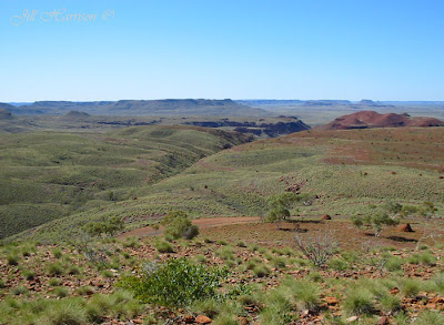
The State’s second biggest national park, Karijini covers 627,445 hectares. Much of the southern half of the park is inaccessible, so visitors concentrate on the spectacular and rugged gorges in the north that plunge hundreds of metres from the Spinifex plains.

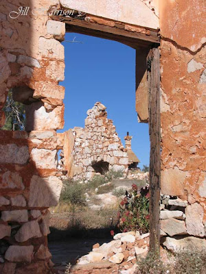
Karijini was first explored by FT Gregory’s party in 1861. The traditional owners, the Banyjima, Yinhawangka and Kurrama Aboriginal people, call the Hamersley Ranges, Karijini, so the park’s name recognises this historic link and their continuing involvement in park management.

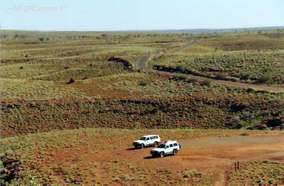
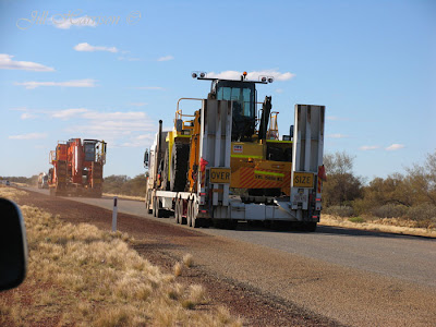
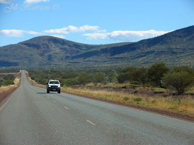
Here we are driving through the park.


From Life Images by Jill

There are a number of gorges and walk trails to explore at Karijini. These range from short, easy walks for people of all ages and fitness levels, tracks for those with moderate fitness, to trails which should only be attempted by fit, experienced, well-equipped bushwalkers. It is a good idea to study the information boards before setting out, allow plenty of time, wear sturdy hiking boots and carry plenty of water.

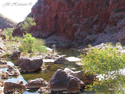
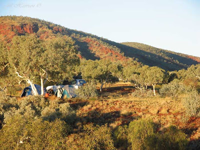
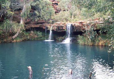
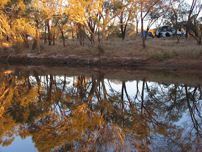
The camp ground where we are going to set up camp is within walking distance of Dales Gorge. The walk trail into Dales Gorge takes you 800 metres down into Fortescue Falls and Fern Pool, and two kilometres through Dales Gorge to Circular Pool, before climbing the steep ascent out of the Gorge. Fortescue Falls is spring-fed and is the Park’s only permanent waterfall.

Here is Fortescue Falls from the rim of Dales Gorge....

From Life Images by Jill
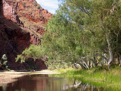
The Falls tumble over layers of iron-stone rock from the tree lined Fern Pool. A wooden walkway takes you right to the waters edge and the pool is a perfect place to sit in the shade or have a swim to cool off.

This is Fern Pool.....

From Life Images by Jill

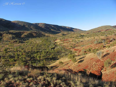
The trail following the creek from Fortescue Falls to Circular Pool is not difficult and visitors should allow a day to fully experience the Gorge. Built up over millions of years, the layers of multi-coloured rock of the cliff faces tower over clear rock pools and shady meandering pathways, which are a refreshing retreat from the arid Spinifex plains above you. There are plenty of places to sit and enjoy the beautiful landscape.

The pathway from Dales Gorge...

From Life Images by Jill

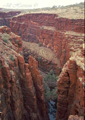
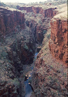
About 40kms west of Dales Gorge is the junction of Joffre, Hancock, Weano, Red, Wittenoom and Knox Gorges. Easily accessed lookouts give a spectacular view of what the forces of nature can do to the landscape. The Joffre Waterfall plunges hundreds of metres forming a natural amphitheatre.

Fit and more experienced walkers can follow trails down into and through the gorges. Walkers should be careful as trails may be unmarked, and go over steep, slippery and unstable surfaces. Flash floods can occur and it is not recommended to enter the gorges if there is rain in the area, and to leave as quickly as possible if it does rain. However you don't have to climb down into the gorges to enjoy them as the following views will show you.

This is one of my favourite shots from Karijini - however don't do as I did to get this shot...I climbed over the railing....much to my husbands distress - he was right of course - the railing is there for a reason. However it was the only way to get this angle and I am here to tell the tale. I love the fingers of red rock, and the blue water and the tree at the bottom.

This is Hancock Gorge.

From Life Images by Jill
And Knox Gorge.....

From Life Images by Jill
And the view from Oxer lookout....

From Life Images by Jill

And this is walking through Kalamina Gorge - one of the easier gorges to climb into and walk through. I must say photography in these gorges is problematic with the shade below and the bright light above. Next time I will try a graduated filter, but for these I have had to do a bit of pp to adjust lighting.

From Life Images by Jill

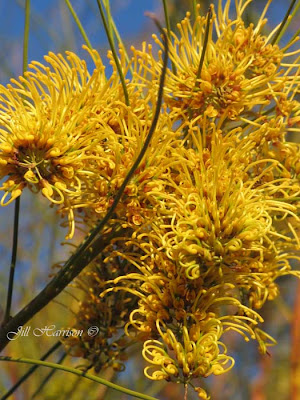
Karijini offers it all. Spectacular landscapes. Enough walk trails to satisfy the most avid hiker. Rock pools to cool off. Stunning sunrises and sunsets. Beautiful wildflowers. Unlimited photo opportunities. Peace and quiet. And at night a blanket of stars.

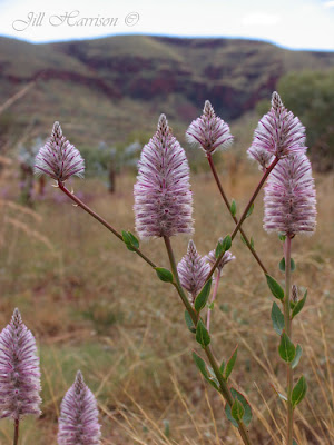
Well, the title said "red rock and spinifex". I have shown you the red rock, so here is the spinifex (well the seed heads anyway), taken in early morning light when we got up to see the sunrise over Dales Gorge.

Spinifex is very prickly to walk through - and feels like a tough plant, but really it is quite delicate because evidently if you stand on it the plant will die. Many small animals depend on the spinifex plant.

If you look at the previous photos the creamy coloured clumpy plants on the ground above the gorge are all spinifex. You can see some in the foreground of the photo of Fortescue Falls.

From Life Images by Jill

It really is amazing to stand in these places - I especially love sitting out at night under the blanket of stars gazing up at the Milky Way - so much clearer and brighter than in the city. And I love the quiet and the chance to just absorb what is around me - very rejuvenating - but so difficult to go home and return to work!

Tuesday, July 6, 2010

Week 27/52- Part 2 - Gascoyne & the Pilbara - River camp and iron ore

Good morning everyone. I have decided I need to include Part 2 of week 27, because I have a few extra photos I wanted to share. We are continuing north along the Great Northern Highway, and these photos are between Cue, our last destination, and Karijini National Park, our next destination.

Here is our camp for the night - the Gascoyne River. It is my favourite free camp heading north and we have camped here several times. Because it is a free roadside camp there are no facilities, but the beauty of the camp site always makes it a place we enjoy. We have a fire and cook marshmallows over the coals. It is gorgeous to wake up to the sound of bird song and the rising sun streaming through the trees.

Here is a photo I took early morning with a perfect reflection on the river, looking across to our camp.

From Life Images by Jill

Another photo from the Gascoyne River camp. The water level in the river rises and falls dependant on the season. You can see the bare roots of the trees on the river bank.

From Life Images by Jill

Although I love the Pilbara, I have a hard time driving up here because of road trains. These massive trucks take up a lot of road space both in width and length. Sometimes they have 4 trailers on behind the prime mover. You need a lot of clear straight road to be able to pass. You see lots of them coming either direction carrying machinery like this one, or covered trailers carrying supplies to the northern towns. My husband knows they make me very uncomfortable trying to pass so he does most of the driving up here. We had already passed this convoy down the road and when we stopped to get fire wood they went past us again. Lucky we were near to camp.

From Life Images by Jill

Newman is the centre of the iron ore region. This is one of the iron ore trucks. Huge aren't they?

From Life Images by Jill

This flower is the Mulla Mulla. You know when you have entered the Pilbara when you start seeing the Mulla Mulla. They are everywhere. There are different varieties ranging from this larger one, to smaller ones, also white. That is the Hamersley Ranges you can see in the background of this photo.

From Wildflowers

This is driving through the Hamersley Ranges - they are rich in iron ore and recognised as one of the oldest weathered surfaces on earth. The ranges are notable for their distinctive horizontal bedding where layers of red, black and brown iron form bands of colour with conglomerates and sandstone.

From Life Images by Jill

And this is an iron ore train we had to stop for - I forget how many carriages I counted, but it took a long time to cross. These trains are commonly 2 km long and have three diesel engines hauling 200 cars each of which carries 100 tonnes of ore. - approximately enough iron ore to construct about 15 000 family cars.

From Life Images by Jill

Friday, July 2, 2010

Week 27/52 - Cue, Queen of the Murchison

Hi everyone, and welcome to week 27 of our 52 week Tour Downunder Western Australia.

This week we drive east of Yalgoo to the Great Northern Highway and then north to Cue - Queen of the Murchison.

Gold was first found in Cue on New Years Day 1892 by Mick Fitzgerald. The alluvial patch became the scene of a huge gold rush, coinciding with the gold mining boom of the 1890's and early 1900's throughout Western Australia.

Cue is now a living example of the past and present, and is well worth the time to visit.
Cue's heritage trail retraces the early development of the district and its role in the gold-mining era, including many buildings constructed at the turn of the century - Cue's rich history has been preserved in these magnificent buildings.

This is the Cue government buildings, with the town clock and post office, located in the centre of Cue on the Great Northern Highway. Built in 1896, these buildings were made of locally quarried limestone slabs and were designed to house the offices of a number of government departments such as the Wardens Court, Post Office and Police Station.


From Life Images by Jill

This is the former "Gentleman's Club" (restored in 1986) - now the Cue Shire Offices and Visitor Information Centre.

From Life Images by Jill

This is the Great Fingall Mine Offices at Day Dawn mine, built by Italian stonemasons in 1902. There is an open cut mine behind this building, although the mine closed in 1918, after being the premier gold mine in WA at the time.

From Life Images by Jill

And the old hospital ruins. The first doctor in Cue, Dr Monteath, was appointed in 1892. Assisted by his wife, he worked under a canvas and bough shed until the hospital was built in 1895 from local stone. The hospital closed in 1942 and now only a few ruins remain.

From Life Images by Jill

here are a few more photos from around Cue - where we are going to camp tonight - next to Lake Nannine just north of Cue where you can free camp overnight.

From Life Images by Jill

You have seen a field of pink everylastings, a field of yellow everlastings, now here is a field of white everlastings -

From Life Images by Jill
And a closer view -

From Wildflowers
And an emu we spotted by the roadside -

From Life Images by Jill

Here is another photo from Cue - I have fiddled with this one a bit in Photoshop Elements to give it a different look - not something I do a lot of (as you can probably tell!)

This is the Masonic Lodge built in 1899 of timer and corrugated galvanised iron, with a pressed iron interior. Corrugated iron was used extensively in the goldfields during this time as it was easily transported by camels. Very few buildings of this type remain in Australia.

From Life Images by Jill